Ben Tyler - Trail # 606
Beginning Elevation: 8260
High Point: 11650
End Elevation: 9550
Difficulty: Moderate
Length, One Way: 11.1 miles
Seasons: Summer through Fall
USGS Quads: Shawnee, Mount Logan, and Observatory Rock
Other Maps: Pike National Forest, Trails Illustrated #105
Usage Level: Medium
Access Trail Heads: North Ben Tyler, Rock Creek
Connecting Trails: Craig Park, Colorado Trail
DESCRIPTION
This popular trail offers excellent views to the north and south from its high point, and the changing colors in September, particularly in the large aspen groves in Ben Tyler Gulch, are outstanding.
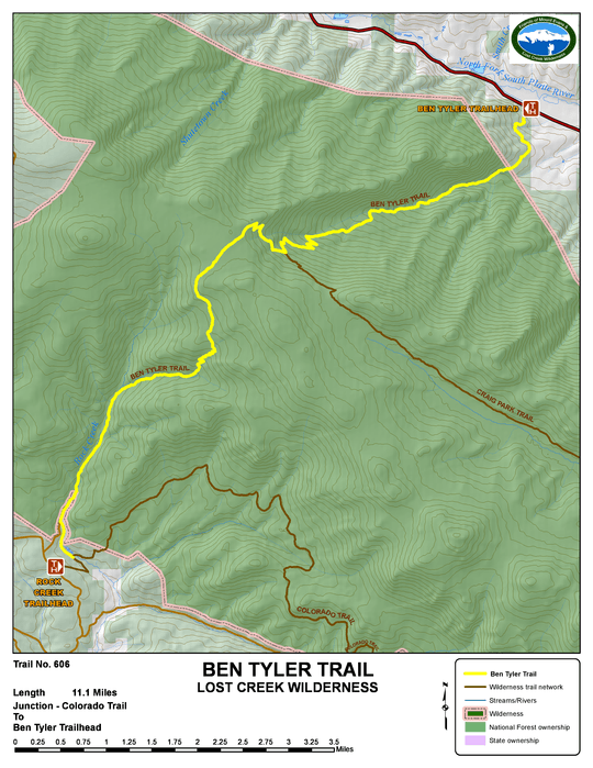
Beginning at the North Ben Tyler Trailhead, the trail climbs steeply in a series of switchbacks. Please do not cut across these switchbacks. After the last switchback, the trail becomes less steep up to a crossing of Ben Tyler Creek. At this point the trail gradient increases and the valley tightens. There are limited areas along this section of trail suitable for camping. The final section up to the Craig Park Trail junction is a series of long switchbacks that, when traversing east, offer long views down Ben Tyler Gulch. The Craig Park Trail junction is marked by a sign indicating the Craig Park Trail to the left (east), and the Ben Tyler Trail to the right (west). The trail continues to climb, crossing Ben Tyler Creek again, to a high saddle above treeline, which offers some spectacular views. From here the trail descends to the south into the Rock Creek drainage. Just past the Wilderness boundary you reach the end of a closed forest road. Continue hiking down the road and, where the road leaves the creek, continue following the trail down along the creek to join the Colorado Trail.
TRAIL'S HISTORY
The trail is named for Ben Tyler, who lived with his family in the gulch that bears his name. He operated a lumber mill during gold rush days, hauling the timber down the gulch to the railroad in the valley. Later, after a 3,000 acre fire swept the gulch in 1903, more lumbering was done toward the head of the gulch to salvage the burned timber. This fire was responsible for the huge aspen grove in the gulch.
There was also logging on the Rock Creek (south) end of the trail. About a mile inside the Wilderness boundary on the south end, are the remains of an old lumber camp. In addition to logging, there was grazing along Rock Creek as evidenced by an old cattle herder’s line shack just north of the end of the trail at the Colorado trail junction.


