
roosevelt lakes - trail #56

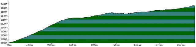
Beginning Elevation: 11000
High Point: 11950
End Elevation: 11950
Difficulty: Moderate
Length, One Way: 2.2 miles
Seasons: Summer Through Fall
USGS Quads: Harris Park
Other Maps: Arapaho National Forest, Trails Illustrated #104
Usage Level: Low
Access: This trail has no trailhead, but is accessed via the Beartrack Lakes Trail or the Tanglewood Trail.
Connecting Trails: Beartrack Lakes, Tanglewood
Description
The Roosevelt Lakes Trail accesses two beautiful alpine lakes sitting in a cirque on the northeast side of Mount Rosalie. From its junction with the Beartrack Lakes Trail near Lower Beartrack Lake, the trail climbs steeply onto the northeast shoulder of Mount Rosalie at timberline. Climbing more gently southward around the shoulder, the trail soon reaches the Roosevelt Lakes at 11,742 feet and continues less than a mile to the saddle between Mount Rosalie and the Pegmatite Points. At this point the trail becomes the Tanglewood Trail and drops into the trees and descends southward into the Deer Creek drainage.
TRAIL'S HISTORY
Just when it was constructed is uncertain, but it is likely it developed over time, probably even before the establishment of the National Forest, as a way to access the Upper Bear Creek Basin from the Deer Creek valley. The July, 1919 issue of Denver’s “Municipal Facts Monthly” mentions, “An old trail up the creek leads over a low pass on the east side of Rosalie Peak, and drops by easy stages into the Bear Track Lake country, formerly one of the best entrances into that beautiful camping and fishing region. It is a natural route for a road.” Fortunately, that road never came to pass. A 1979 Forest Service document refers to the Roosevelt Lakes trail as the Pegmatite Pass trail.