
Brookside -McCurdy - Trail # 607

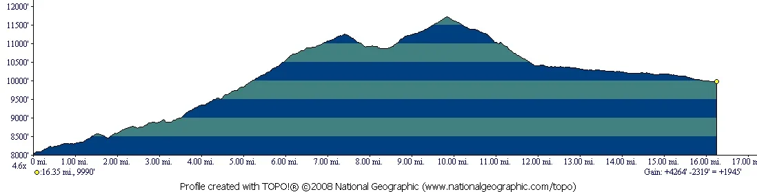
Beginning Elevation: 8040
High Point: 11880
End Elevation: 7560
Difficulty: Difficult
Length, One Way: 32.1 miles
Seasons: Summer, Fall
USGS Quads: Shawnee, Topaz Mountain, Farnum Peak, and McCurdy Mountain
Other Maps: Pike National Forest, Trails Illustrated #105
Usage Level: Medium
Access: Also connects with unlisted trail: Brookside AG.
Access Trailheads: Payne Creek/Brookside, North Fork, Lost Park, Twin Eagles
Connecting Trails: Payne Creek, Craig Park, Colorado Trail, Wigwam, Ute Creek, McCurdy Park, Lake Park, Hankins Pass


Description
The Brookside-McCurdy Trail is the major north-south artery through the middle portion of the Lost Creek Wilderness. Along the way it connects with nine other trails, providing numerous opportunities to create loop trips of various lengths. Throughout its length, this trail presents the hiker with a wide variety of the different landscapes found in the Lost Creek Wilderness, including different forest types, wide-open parks, wild formations of red Pikes Peak granite, and tremendous views. Deer, elk, and bighorn sheep are some of the wildlife that may be seen along the trail.
Starting from the Payne Creek/Brookside Trailhead, the trail rises gently and soon reaches the junction at which the Payne Creek and Brookside-McCurdy trails diverge. The Payne Creek Trail goes left and the Brookside-McCurdy continues south, climbing gradually at first, and then steepening as it climbs the Platte River Range. After crossing the boundary of the Lost Creek Wilderness, the trail eventually meets the Brookside AG Trail, which rises up from the west after leaving MacArthur Gulch. From here, the Brookside trail continues to climb up and over into Craig Park, where it intersects with the Craig Park Trail.
The next segment rises south out of Craig Park over a saddle, and then descends into North Lost Park, where it leaves the Wilderness and joins the Colorado Trail. A couple of miles down valley from this junction, the North Fork Trailhead is reached and the two trails part. The Colorado Trail runs east and north to the Rolling Creek Trailhead and the Brookside-McCurdy veers south following North Lost Creek to the Lost Park Trailhead.
From Lost Park the trail goes south across Lost Creek to a junction with the Wigwam Trail. The Wigwam Trail goes left (east) and the Brookside-McCurdy continues south and soon re-enters the Wilderness, following Indian Creek upstream to a high saddle between the Lost Creek and Tarryall Creek drainages, where it meets the Ute Creek Trail from the south. Here the trail swings southeast, continuing to climb for a short distance to its high point on the southwest shoulder of Bison Peak. From the high point, the trail follows a ridge to the southeast through the remnants of an old burn. This stretch has tremendous views to the south and west, particularly in the Fall, but be aware of your exposure to lightening from summer afternoon storms. Eventually the trail drops down to the pass at the south end of McCurdy Park and meets the McCurdy Park Trail.
The trail then descends a short distance to a junction with the Lake Park Trail. The Brookside-McCurdy continues south, dropping steeply and leaving the Wilderness, to a junction with the Hankins Pass Trail. One last gentle downhill leg brings you out at the Twin Eagles Trailhead.
TRAIL'S HISTORY
The trail originally was two, the Brookside on the north end, and the McCurdy on the south. The north end of the trail used to begin to the west of the current trailhead about a mile, climbing up the ridge west of Brookside creek on an old road up to a lumber camp. Because the trail began on private land, it was rerouted in the mid-1990s to the present trailhead.
About a 1 ½ miles in from the trailhead, the Payne creek and Brookside trails divide at the bottom of an open meadow. Above the junction on the north side of the meadow is a concrete slab that marks the site of CCC camp F-10-C. The short-lived CCC camp was established in the spring of 1933 by Company 1814, but only lasted until December of that year.
Returning to the logging road on the ridge west of Brookside Creek, the trail passes the remains of an old logging camp before crossing over the crest of the Platte River range and dropping into Craig Park.
Just east of the North Fork trailhead in North Lost Park lies the remnants of W. W. Hooper’s sawmill. In 1887 Hooper spent $1700 constructing the Hooper trail, now the Colorado trail, to haul lumber over to the railroad at Estabrook, just east of Bailey.
Between Bison Peak and McCurdy Park, the trail passes through a ghost forest, the remains of a large forest fire in the late 1860’s.