
hankins pass - trail #630

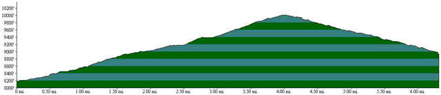
Beginning Elevation: 8200
High Point: 10000
End Elevation: 8960
Difficulty: Moderate
Length, One Way: 6.5 miles
Seasons: Spring, Summer, Fall
USGS Quads: McCurdy Mountain
Other Maps: Pike National Forest, Trails Illustrated #105
Usage Level: Medium
Access Trailheads: Goose Creek
Connecting Trails: Resthouse, Lake Park, Brookside-McCurdy, Lizard Rock
Description
The Hankins Pass Trail is the southernmost trail in the Lost Creek Wilderness. From the east, the trail passes through dense forest to pleasant open meadows and aspen groves. From the junction with the Lake Park Trail at the top of Hankins Pass, the trail drops down the west side of the Tarryall Mountains to a junction with the Lizard Rock Trail, and then continues to descend to meet the Brookside-McCurdy Trail.
There are horse corrals near the Goose Creek Trailhead that are available for public use. There are a number of campsites between the trailhead and Hankins Pass. However, there are few areas suitable for camping west of the pass due to the steep gradient of the trail.
From the Goose Creek Trailhead, hike downhill to a footbridge across Hankins Gulch. Just across the creek, the Hankins Pass Trail heads west (left), while the Goose Creek Trail goes east (right). Climbing at first up through a forested valley, the trail eventually reaches a series of open meadows surrounded by aspen groves. The trail from here to the pass is beautiful in late September when the aspen leaves are changing color. At the top of Hankins Pass is a junction with the Lake Park Trail, which heads north (right) toward Lake Park, while the Hankins Pass Trail begins it's descent to the west.
The grade on the west side of the pass is quite a bit steeper than the gradual rise up to the pass from the east. After a short descent, the trail reaches the wilderness boundary and the junction with the Lizard Rock Trail. The Lizard Rock Trail leads south to the Spruce Grove Campground, while the Hankins Pass Trail continues down in a northwesterly direction to its end at the junction with the Brookside-McCurdy Trail.
TRAIL'S HISTORY
Little is known of the history of the Hankins Pass trail, although a few old fences suggest that it may have originally been an old cattle trail from the Goose Creek area west over Hankins Pass and into the Tarryall valley.
The east end of the trail was burned in the Hayman Fire of 2002 but, although the burn can be seen on the slopes above the trail most of the way to the top of the pass, the fire generally stayed out of the bottom of the valley along Hankins Creek.